A military trail commemorating Hauptmann Theodor Bernatz, the Austro-Hungarian Army officer who longest-held command of the Nardìs Subsector.
This almost level high-altitude trail stretches between the Seyfriedhütte at 2,550 m and the windswept Ganöta mountain saddle at 2,565 m – a gap nestled to the north-west of the Cima Tamalè peak. Here, time is measured by the slow disintegration of the rock itself and, with a careful eye, distinct sections of stone paving can still be made out: tangible evidence of military engineering, designed to bear the weight of men and mules while preventing the constant ground slippage, thus ensuring a stable passage.
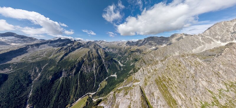
Before long, the trail reaches the strategic Ganöta posts, where the eye is struck by a vast panorama in which geology and history merge into a single embrace. Much of the Adamello Group lies below, with the gaze dropping into the deep incision of the Val Genova valley and its side vales – Germenega, Siniciaga, Làres, Folgorida and Stablel. Towering above, like a sleeping giant, rises the Vedretta di Làres glacier, dominated by the imposing Carè Alto mountain, the legendary Corno di Cavento mountain and the jagged Crozzon di Làres mountain. To the north, the upper Val di Nardìs valley frames the majestic Cima Presanella peak. In wartime, this walkway ran along the entire Tamalè ridge, linking - also by means of scaffolding and rope-fixed sections – the ridge posts and artillery emplacements as far as the cableway station at the Passo Scarazzon delle Rocchette pass.
To reach the trail starting point at the Seyfriedhütte, locally known as ‘Plan da li barachi’ (Plain of the barracks), you must first traverse a large part of the Val Nardìs valley (Val Nardìs – La Via delle Valli), passing the Malga Nardìs and Malga Fiori hut, and then follow more than half of the Landesschützen Trail.